|
Safety and Responsibility
Water Levels Camping & Lodging Amenities & Attractions Wildlife Mapillary Imagery If you would like to experience the West Nishnabotna River Water Trail, check out the interactive Google map at the bottom of this page or click here to download a pdf brochure.
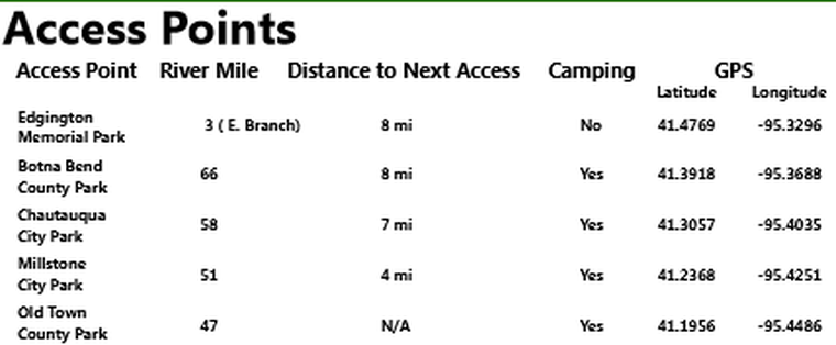
Accesses are located at:
Parking is available near each access. Interpretive panels like the one below help visitors learn about the river. 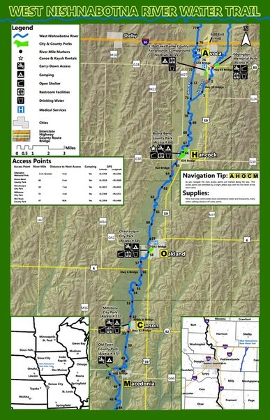
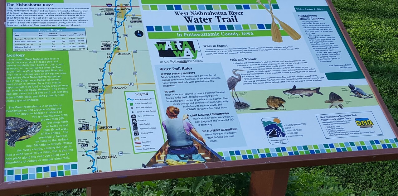
Equipment Rental and Shuttles Want to experience the water trail but don't have the equipment? Two outfitters are located along the water trail: The Water Trail Experience The first three miles between Edgington Memorial Park in Avoca and Botna Bend Park in Hancock are located on the East Branch of the West Nish, hence a different numbering system for miles. It has a smaller channel than the main branch, offering a different environment than the rest of the trail, including great tree canopy much of the way. You will cross three bridges--Highway 83, Highway 59, and an abandoned railroad bridge--before reaching the confluence with the main branch of the West Nishnabotna. You will also pass under some large transmission lines between the two highway bridges. At this confluence, the river widens and then meanders for several miles to Botna Bend Park in Hancock. Immediately after the Hancock access is the Highway G-30 bridge, followed soon after by the Iowa Interstate Railroad bridge. A few miles downstream you will probably notice some pipes on the east side of the river discharging effluent into the river. This is a meatpacking plant and at this point you're about two miles from Oakland. After a sharp bend in the river you will cross under the Highway M-16 bridge and quickly reach Oakland's Chautauqua Park access. About a mile south of Oakland is the Highway 6 bridge, and about five miles downstream from that is the 400th Street bridge, followed soon after by the Millstone Park access in Carson. On the south side of Carson you will pass under the Highway 92 bridge. Almost three miles downstream from Carson is a unique geological site called the "rock cut." While most of the West Nish streambed is located in deep loess soils, the underlying bedrock is exposed at the rock cut when the water level is low enough. This location offered a great site for pioneers to cross the river, including the Mormon Trail. The river was channelized in the early 20th century and some sections are still relatively straight, while others have started to meander again. On many bends you will see extreme streambank erosion, and in some places rowcrops are actually falling into the river. This is due to channel degradation that is still occurring because of the prior channelization. Many small tributaries can be seen emptying into the West Nish throughout the route, the largest being the confluence of the East Branch and West Nish south of Avoca. Each access has a yellow sign with a black letter for the town name (A for Avoca, H for Hancock, O for Oakland, C for Carson, and M for Macedonia). Make sure you know where you're exiting so you don't miss it, as paddling upstream is not easy. Yellow mile markers are located in trees every two miles on the water trail, but can be easy to miss if you're not watching. Click here to view photos of the water trail at Mapillary. If you have questions or concerns about the water trail, contact Lance Brisbois ([email protected]/712-482-3029). 
Look for the signs located at each access with the first letter of each town name.
Interactive Map |
