Water Levels
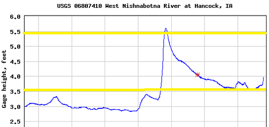
The USGS has a river gage in Hancock that is updated every 15 minutes. To view current river levels, see the chart below or click here. An ideal level for most paddlers is between 4 and 5 feet at the Hancock gage. Below about 3.5’, paddlers are likely to scrape the bottom a few times. Below 2.5 feet gets difficult to paddle and will require walking. Under 3 feet is difficult to float for tubes. Above 5 feet, the current may be too strong for beginning paddlers, and more experienced paddlers should be extra cautious. The depth can also vary greatly in a small area. An inside bend may be only a few inches deep while an outer bend on the other side of the river could be several feet deep.
The West Nish tends to be very "flashy," rising and receding rapidly with precipitation and snowmelt. A few inches of rain the watershed upstream can cause the water level to increase drastically in just a few hours, but it typically lowers quickly too. Keep in mind that water from nearly 500,000 acres drains into the West Nish above the water trail. It may not rain in Pottawattamie County, but a large storm upstream could cause river levels to rise significantly. Check the gage and weather forecast several days in advance to familiarize yourself with how quickly the water level can change.
Depending on recent weather conditions, the water level could vary north or south of Hancock. If water is covering most of the access ramp, then it is likely unsafe for paddling. Use your best judgment to stay safe. State law requires each person to have a personal flotation device with them at all times while on the water.
Current Level at Hancock
Example
The chart below is an example of how the gage can change over several weeks. Generally safe and comfortable water levels for beginning paddlers are located between the yellow lines. These levels are measured at Hancock, and levels upstream or downstream could vary.