About the West Nishnabotna RiverThe West Nishnabotna River Valley has had and continues to have significant impact on local communities.
Geology & Natural History The West Nishnabotna River watershed covers more than 1,600 square miles in parts of nine Western Iowa counties. At its headwaters in Carroll County, the river is a mere trickle of a stream. As it flows southward, the river grows progressively larger as numerous tributaries flow into it.
Some of the largest tributaries include the East Branch of the West Nishnabotna (near Avoca), Silver Creek (near Malvern), and Walnut Creek (Fremont County). At its confluence with the East Nishnabotna River in Fremont County, the Nishnabotna River is born. This river flows several miles through Northwest Missouri before entering the Missouri River. The West Nish is located within the rolling hills of the Southern Iowa Drift Plain, with highly-erodible deep loess soils that were once covered with tallgrass prairie. Today, most of this land is used for corn and soybean production. Near Hamburg, the river passes through the Loess Hills, a landform found only here and in the Yellow River Valley of China. From there, it flows across the wide, flat Missouri River Alluvial Plain. The river was channelized in the early 20th Century to reduce flooding. While channelization did reduce flooding, it led to several other problems that are still apparent today. Streambank erosion is still occurring in many places, and the channel has downcut 10 to 15 feet in many places. Several city, county, and state parks and wildlife areas are located along the river. These provide opportunities for fishing, hunting, wildlife watching, and more. Several communities along the trail have hiking and biking trails as well. Wildlife is abundant along the West Nish corridor. Visit the Wildlife page to learn more. |
Although it is located near a metropolitan area of almost one million people and crosses two cross-country interstate highway systems, the West Nish valley is largely rural and offers a peaceful respite for residents and visitors.
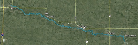
With few exceptions, the land along the West Nish valley today is privately owned and used for commodity rowcrop production. In many places, though, woodlands or pasture border the river, providing scenic views and abundant wildlife. Numerous small, rural communities are located near the river, many of which were established along railroad lines that formerly traversed the valley. Aside from Harlan and Shenandoah, all of these communities have fewer than 2,000 people. The river is used for recreation by many people. It is a state-designated water trail in Pottawattamie County from Avoca to Macedonia. The West Nishnabotna River watershed is part of a project to reduce flooding impacts and improve water quality. Click here to learn more about this project. Fun FactsC.W. McCall has a song about the West Nishnabotna. Not the most flattering lyrics, but a funny tune.
Matt Cox, a local musician, has an album and song called Nishnabotna.
|